The spectacular 38km mountain pass between Barberton and the Josefsdal border post with Swaziland has been developed as the Barberton Makhonjwa Geotrail. It is a self-drive trail through the Barberton Makhonjwa Mountains World Heritage Site, displaying information about the area’s remarkable geology and it’s links to the plant diversity and history. The twelve landscaped lay-bys with interpretative panels and picnic stops have been combined with rock specimens, geological features, and view points to tell the story of how the early Earth evolved some 3.6 billion years ago. The tarred road cuts through some of the most spectacular scenery in the country. Combined with a well-illustrated guidebook (available at the tourism office) and a website, the trail can take anything from two hours to a day, depending on the size of your picnic basket and level of interest.

The route is further linked to the Barberton Gateways in town that draw their design inspiration from the local outsider artist Nukain Mabuza’s colorful painted rock garden at Revolver Creek. It also forms part of what has been coined the Genesis Route, another scenic self-drive that snakes like a figure 8 through the mountains connecting Barberton, Badplaas and Low’s Creek. These three tourism facilities have been developed by the BATOBIC Programme, a project of the Barberton Chamber of Business, funded by the National Department of Tourism and the Chamber.

The Geotrail displays and interprets the oldest and best preserved sequence of volcanic and sedimentary rocks on earth. This unique record of the early formation of the planet and its exceptionally rich diversity of plant species, are set in the spectacular scenery along the route. It is these attributes that have led to the inscription of the Barberton Makhonjwa Mountains on the UNESCO World Heritage list in 2018. Read more …
This geological formation that is home to some of the best preserved Archaean rocks in the world contains significant geological heritage sites that enable scientists to understand the early Earth processes. The Geotrail’s education component and popularisation serves as mechanisms that make it possible for the general public to recognise the value of geoheritage.
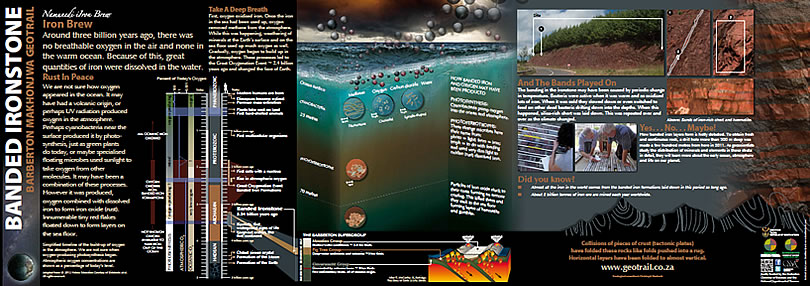
The Geotrail displays the three major rock units of the Barberton Greenstone belt: the Onverwacht Group, followed by Fig Tree and Moodies Groups. The Onverwacht Group is at about 3,570 to 3,300 million years old. It consists mostly of dark green and black former lava flows stacked on top of each other many kilometers thick; some of the hottest lava ever to have flowed on the face of the planet. Some of them show “spinifex texture”, named after the needle-like Australian grass and caused by needle-like crystals of olivine and pyroxene which formed when the lava was quenched in contact with water. Yet between the lava flows exist seams and beds of black former deep-sea sediment which contains microscopic remnants of life that must have floated in the oceans even back then.
A fifty-page guidebook that expands upon the geology and Geotrail is available at the Barberton Tourism Office in town. Click here to download
GEOTRAIL MAP
